- June 28, 2016
- Posted by: ncorporation
- Category: Press Release, Uncategorized
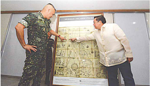

Camp Aquino, Tarlac City—Asian Institute of Journalism and Communication Chairman and NOW Corp. CEO Mel V. Velarde has turned over the first official life-size replica of the famed 1734 Fr. Pedro Murillo-Velarde Map to Northern Luzon Command’s (Nolcom) Lt. Gen. Romeo Tanalgo.
The map’s official name is “Carta Hydrograpica y Chorograpica de las Filipinas.” One of its unique features, aside from its accuracy in the topography of the Philippine islands, is it shows the disputed Scarborough Shoal, also known as Bajo de Masinloc, as a part of the Philippine territory.
“Little did we know that almost 300 years later, those rocks that were drawn on this to specifically guide Spanish ships from sinking, will now be significant and crucial to the destiny of this nation,” Velarde emphasizes on the map’s role it played as an evidence to the Philippines’s claim on the islands at the United Nations Convention on the Law of the Sea (Unclos). “From the utterances of the United States and G7 [Group-of-Seven] nations, and from the utterances of China, itself, it seems that the result would be, most likely, favorable to us.”
Velarde further explained the importance of giving a replica of the map to Nolcom: “The Northern Luzon Command is the protector, watcher, caretaker and defender of our northern territory, where Bajo de Masinloc is under its jurisdiction. This is our own way of helping you, helping the nation and to recognize the proud members of Nolcom—sometimes we sleep without really knowing who are the people always ready to die for us.”
“Why are we fighting for those rocks? Those rocks represent what this nation is all about,” Velarde passionately expressed his thoughts to the members of Nolcom, “that we, as one nation are indivisible, that our territory is sacred to us, that when our patriarchs were fighting for this country, they were not just fighting for one territory alone. They fought for a nation, which was still a seed in their minds that blossomed into a nation that is today called Filipinas.”
“If that rock falls in someone else’s hands permanently, then we would be in proximity to something
antithetical to our beliefs as a people,” Velarde explains further, “that our freedom is universal and we cannot accept the loss of freedom—something our forefathers so bloodily fought for, and we are still willing to fight for. Like with Tibet and Mongolia, getting closer to us is a hungry giant, which is why we need to defend our state of being. Unlike this giant neighbor, we Filipinos “believe in freedom and liberty, where the acts of governments must be subject to the consent of the governed—always!”
“Patriotism can take many forms,” Tanalgo said, “In the case of Mr. Velarde, the exhibited act of patriotism is unique and unmatched. Ensuring that the map landed on the hands of the Filipino people, he shelled out his personal wealth and simply bought it. He bought it for our country to rekindle the sense of patriotism among our people—to promote our sovereignty and support national interest in the West Philippine Sea.”
“I pray that this map serves as a point of existential value for all Filipinos, regardless of provincial descent, tribe, belief, religion and social stature. Sir, you spent wealth for this map,” Tanalgo told Velarde. “You pay our soldiers with your taxes, and we will repay you with our blood and commitment.”
Source: http://www.businessmirror.com.ph/1734-phl-map-turned-over-to-nolcom/